Case Study - (2023) Volume 12, Issue 3
Received: 03-Feb-2023, Manuscript No. SNDC-23-93567;
Editor assigned: 09-Feb-2023, Pre QC No. SNDC-23-93567;
Reviewed: 23-Feb-2023, QC No. SNDC-23-93567;
Revised: 03-Mar-2023, Manuscript No. SNDC-23-93567;
Published:
31-Mar-2023
, DOI: 10.37421/2090-4886.2023.12.189
Citation: Gomez, J R M, E Jr B Leron, A B Ikutanim and P J E
Abagon, et al. "Monitoring the Natural Vegetation of Boracay through
Land-Based Segmentation Using Satellite Images." J Sens Netw Data
Commun 12 (2023): 189.
Copyright: © 2023 Gomez JRM, et al. This is an open-access article distributed under the terms of the creative commons attribution license which permits
unrestricted use, distribution and reproduction in any medium, provided the original author and source are credited.
This study focuses in building a script that will analyze the condition of natural vegetation in boracay using satellite images through artificial neural network. The designed program is created to help user assess and preserve the area without consuming so much time. The levels of condition were determined as vegetation, Infrastructure, and Water. The researcher constructed the artificial neural network by the help of MATLAB application. With the use of the images gathered from satellite images, the researchers were able to produce result of vegetation, Infrastructure, and water in percentage form.
Satellite images • Neural network • Infrastructure • MATLAB application
As boracay turns to be a tourism driven city, simultaneous infrastructures’ developments are expected which in return could deteriorate its vegetation percentage. An Artificial Neural Network (ANN) trained to identify the vegetation percentage is an initial step for the monitoring and preservation process of boracay's natural resources in cooperation with the local authorities. The use of satellite images would enable the process of consistent monitoring of vegetation and non-vegetation areas. That is the sole purpose of the ANN developed [1].
ANN or artificial neural network is a trained system that is used to analyze certain data. In the researchers’ study it is the identification of the natural vegetation, infrastructures and water areas. In order to truly understand how the system works, the researchers gathered several related literatures from previous studies, articles and journals. Vegetation in any given area would not be stable over long periods of time even without man's influence. In many areas it may be unrealistic to try to define the natural vegetation for a site; one must recognize that there are often several communities that could be the ‘natural’ vegetation for any given site at any given time [2,3].
As for the purpose of the study, the collection of the natural vegetation's data is supposed to use minimal effort and time. Albeit there are traditional methods of collecting the data, it is most likely to be economically impractical and requires intensive labor. ANN can be used to provide sufficient and efficient data because of its systematic observations at various scale, especially at largescale, and it can potentially enable the classification of the variable data that only requires minimal effort [4].
Classifying and mapping vegetation are essential tasks for environmental science research and natural resource management. Traditional methods (e.g., field surveys, literature reviews, manual interpretation of aerial photographs), however, are not effective for acquiring vegetation data because they are labor intensive and often economically expensive. The technology of remote sensing offers a practical and economical means to acquire information on vegetation cover, especially over large areas. Because of its systematic observations at various scales, remote sensing technology potentially can enable classification and mapping of vegetation at high temporal resolutions [5,6].
According to image processing, analysis and machine vision by milan sonka, image processing and analysis based on continuous image transforms is a classic processing technique. These image transforms are basically used in image filtering, image data compression and image description. ANN works by image processing. The visual appearance and the transmission of the data to the observer are improved through image processing. In line with that, image processing also prepares an image for the occurrence of image features, structure measurements and analysis. Image processing helps the observer to identify certain variables by picking up certain cues by visual process [7].
Experimental programme
Natural vegetation applications of ANN in terms of selection of inputs, architecture of networks, training algorithms, and selection of training parameters in different types of neural networks are used for counting and estimating the remaining greens in boracay by satellite image processing. Data collection of boracay island was done by using satellite images for checking the condition of boracay for the past 6 years. The researchers used esris wayback living atlas for the images in determining its natural vegetation. The conditions are described as vegetation, infrastructure, and water [8,9].
To design the artificial neural network, the researchers used the software application MATLAB. The process requires creating a program to be trained using the collected and collage pictures from the satellite (Figures 1-3).

Figure 1. Collage picture of vegetation.

Figure 2. Collage picture of infrastructure.

Figure 3. Collage picture of water.
The training will be done 45 times. Starting from network 3 and will end in network 11, each having 5 trials. The artificial neural network will then produce different values of correlation coefficient “R” in each set of trials. The largest value of coefficient will determine the network that the researchers will use for the official testing. Results will be shown in the form of percentage.
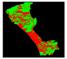
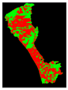
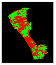
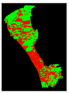
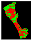
Within the gathering process, data were collected from year 2014-2020. These data are the images that were compiled and were partitioned into three variables: vegetation area, infrastructure area and water area. These clustered images were used for training all the networks. The training is simply for familiarization of input variables. The familiarization of variables was presented as data called as the correlation coefficient R. This R is determined in all the networks; it is the percentage value that states accuracy of input [10]. From 5 trials of 9 networks, network trial1 provided a correlation coefficient R of 0.90891. It denotes that 90.891% accuracy of input was determined. This specific network has the largest value of R and the best fit network in the study [11]. This was used for the actual testing and results were determined. The result/output is simply the output image including the percentage value of the three variables. The output image is still map of boracay but was presented into three set of colors. The vegetation area is observed as green, red for infrastructure and yellow for water area (Table 1).
| Year | Actual image | Results |
|---|---|---|
| 2015 | 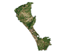 |
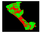 |
| 2016 | 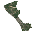 |
 |
| 2017 | 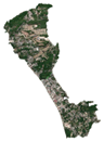 |
 |
| 2018 | 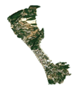 |
 |
| 2019 | 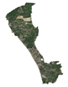 |
 |
| 2020 | 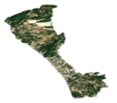 |
 |
Based on the resulting percentage value from year 2014 to 2020 shown in Figures 4 and 5, it can be seen that boracay’s natural vegetation has decreased for 3 years (2014-2020). But re-established its vegetation 2 years after (2017-2019) [12].

Figure 4. Yearly vegetation percentage of boracay.

Figure 5. Best fit line.
Given a 5-year data, a forecast was created through best fit line. Boracay’s vegetation is determined to decrease from 49.1203% in year 2020 to 41.1325% in year 2025. All throughout the study process, researchers have identified the important details that will contribute for the betterment of the study. For technical aspects, use a device that has a high specification. Also, use multiple devices to lessen much time and avoid simultaneous actions in the device. For accurate results, researchers must collect sufficient data, use high-resolution images and be precise in partitioning [13].
Based on the result, the Artificial Neural Network (ANN) system is a convenient tool that reduces the amount of manpower to determine the remaining percentage of vegetation in Boracay by developing appropriate network architecture. It can also be included that the relationship of RGB spectrum has identified through all networks used in ANN. From all the networks, the first and fourth trial of network 4-9-3 has the highest correlation of R=0.90891 (out of the 5 trials) and was used in producing the percentage of variables. The resulting values are very similar to the images with accordance to its timeline gathered from the satellite. By identifying the percentage of vegetation, infrastructure and water, the researchers therefore conclude that the computer-based system using ANN is reliable to use for future monitoring of the Boracay that can remotely assess the percentages of vegetation through the vicinity of boracay using satellite images. Lastly, according to the best fit line, the vegetation in boracay is on a shallow but steady decline from 2015 to 2020.