Research - (2021) Volume 10, Issue 7
Received: 26-May-2021
Published:
30-Jul-2021
, DOI: 10.37421/2168-9768.2021.10.275
Citation: Amare Getnet, Getnet Niguse and Temesgen Enku. "Technical Performance Evaluation of Koga Irrigation Scheme, Tana Basin, Ethiopia." Irrigat Drainage Sys Eng 10 (2021): 275.
Copyright: © 2021 Amare Getnet. This is an open-access article distributed under the terms of the Creative Commons Attribution License, which permits unrestricted use, distribution, and reproduction in any medium, provided the original author and source are credited.
The technical performance evaluation of Koga Irrigation Scheme was made in order to identify management practices for implementation to improve the system operation and the performance of the irrigation system. The evaluation was made based on the selected performance indicators such as water application efficiency, dependability of irrigation interval and sustainability of irrigated command area. The results obtained showed that Application efficiency monitored on three farmers’ farm located on different ends of the command ranges from 52.2 to 61.8% at irrigation scheme. Dependability of the schemes evaluated in terms of irrigation interval shows that the schemes irrigate more frequently than was intended. The sustainability of the irrigated area initially planned for development or the actual irrigated area during the design period was 7,004 ha. However currently it is irrigating about 6,200 ha. This shows that the sustainability of the scheme is 0.86 ~ 86%. In conclusion, on farm water loss was revealed in this study. Relatively highest sustainability of irrigation land value is operating and significant proportion of water is lost on farm areas. Therefore, if structures are in place and water users associations are empowered more in order for it to enforce its bylaws; it will augment the efficiency of the scheme exceedingly.
Irrigation performance • Irrigation institutions • Water application
Ethiopia is known as the ‘water tower of Africa. Its geographical location and endowment with favorable climate provide a relatively higher amount of rainfall in the continent. Preliminary studies and professional estimates put the nation’s annual surface runoff to 122 billion m3, groundwater potential to 2.6 billion m3 and the average rainfall of 1090 mm [1]. However, the spatial and temporal distribution of the rainfall is extremely uneven; these average annual figures give the wrong impression that ‘the country has adequate rainfall for crop production [2]. Despite the endowment of Ethiopia with huge of 3.5 million ha irrigable land the area equipped for full-control irrigation is estimated at 658,340 ha. Among total area used for irrigation of 858,340 ha around 200,000 ha used for community spate irrigation in addition 1,100,000 ha was practiced by small farmers. Thus, in total around 1,958,000 ha is considered to be water managed [3]. This shows that water resources have made little contribution towards the development of agricultural sector in particular and the community in general to date.
In the last few years, heavy investments have been made to harness the water resources of the country towards irrigation development. The Tendaho, Kessem, Fentale, Koga irrigation projects over and above huge work on rainwater harvesting pond construction that has been aggressively pursued all over the country are evidences for the communities’ and government’s commitment to irrigation development. However, given the dismal and undesirable experience on the performance of the irrigation schemes developed earlier, there is no guarantee that the new schemes will deliver the anticipated benefits.To form sustainable irrigation scheme mutual supportiveness of irrigation infrastructure and institutions are needed. Mutual supportiveness is ensured when the hardware is cost and labor efficient, easy to operate, and yielding predictable results. The software is characterized by individual/collective interest and management skill embodied in a lean organization of water users besides adequate support services [4]. Lack of appropriate skill and commitments to accomplish mutual responsibilities on the water user’s side, and inadequate organizational and management setup of the local irrigation scheme managers is the biggest constraint.
The paradox of big expectation from irrigation development to alleviate food insecurity and rural poverty versus inability to sustainably utilize developed schemes calls for detail scrutiny of the relative contribution of prevailing technical and institutional problems of failed schemes [5]. The performance of irrigation scheme has to be evaluated periodically, both at the system- and at farm-levels, using indicators that have been established. The evaluation results as recommendation for maintaining the farms sustainability and economic utilization by saving water resource and may have used to generate new data for design and operation of irrigation schemes. Huge expectation of the irrigation development to alleviate poverty versus inability to sustainably utilize them call for detailed explanation on the relative contribution of technical and institutions that may cause under performance of the irrigation schemes.
In Koga irrigation scheme farmers are over applying water than the actual water demand of irrigation events and these explain the on farm water loss revealed [6]. Their farms off take canals are manipulated by the field owners and thus create ‘artificial demand’. In fact as a result of such ‘artificial demand’ the total designed command areas could not be fully developed. the major portion of the excess diverted water was lost on farm resulted in rising ground water and water logging in some irrigation blocks, which has affected crop productivity [6]. Owing to the fact that almost all the conveyance and distribution systems in Koga scheme are lined and the main canals are wide, the significant proportion of the water lost in the canals would be by evaporation. In view of this finding, it is important to focus on improving the on farm application of the Koga irrigation scheme. Hence, study evaluated the performance of Koga irrigation scheme.
The Study Areas
The study was carried out at Koga irrigation scheme in the Amhara National Regional State (ANRS): (See Figure 1) Koga irrigation scheme is located in Mecha Woreda, West Gojam Zone close to Merawi town; the center of the Woreda, which lies about 35 kilometers southwest of the regional capital Bahir Dar. It serves about 10,000 smallholder households. The scheme has a well organized and coordinated irrigation system with infrastructure that includes a 19.7 km primary canal, 42.3 km secondary canals, 117 km tertiary canals, 783 km quaternary canals and 12 night storage structures for delivering water to each plot of land (Yigzaw Dessalegn & Teshome Derso, LIVES Project, Amhara region) (Figure 1).

Figure 1. Location map of Koga irrigation scheme: Source :- (Birhanu et al., Irrigation Drainage Sys Eng 2015, 4:2).
Technical Efficiency Evaluation
Technical evaluation was conducted using technical efficiency indicators including water application efficiency, dependability of irrigation interval and sustainability of irrigation. Measurements were made on the field, and design figures were reviewed from secondary sources including the design document. The water application efficiency was measured two times during the growing season starting at the initial stage and mid stage of the crop. Purposely from the head, middle and tail ends of the scheme three sample research plots were chosen and all the necessary measurement and data collection were conducted at the scheme. The sizes of each plot were 1,221 m2, 816 m2 and 810 m2. All the plots chosen for the study were planted with the Cabbage.
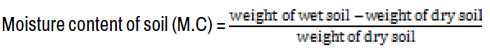
Water Application efficiency: Water application efficiencies of surface irrigation methods was conducted in the Koga irrigation scheme of Amebomesk command area, which is the ratio of depth of water add to the root zone to the depth of water apply to the field. Usually root zone is either assumed or estimated because its accurate measurement is not easy due to several varying conditions. For the current research, the root zone depth for crops under study were taken from the literature (FAO) depending on soil type depth to water tables, etc. and research institutions, which are used for designing and scheduling of the irrigation plan, whereas the depth of applied water (Df) was calculated by dividing the total volume of water applied to area of plot. The water application efficiency was measured two times during the growing season starting at the initial stage and middle stage of the crop, due to assumption of crop water requirements is sensitive on this two stages rather than the harvesting stage. The soil samples were taken from the pits excavated from the Koga irrigation system in Amebomesk command area test plots. For moisture content determination soil samples were taken to the Bahir-dar university high way laboratory two growth stages (initial stage and mid stage) of the crop per plot. For every three plots, soil samples were taken before irrigation and one days after irrigation (where after field capacity of water content in soil is free drainage has taken place) from 0 - 50 cm, and 50 – 80 cm depths per test pit. Due to ranges of maximum effective rooting depth (Zr), for Cabbage is 50 – 80 cm (FAO, 1989). Soil samples were initially weighed with a sensitive balance immediately after sample collection on the field. Water content was then determined gravimetrically by weighing the sample after oven drying at 105oC for 24 hours.
To determine the amount of watr applied by irrigation to the field, Parshall flume FEX 26-5 was installed at the entrance of each test plot (See Figure 2). Frequent readings were taken when the farmers were irrigating the test plots. Irrigating the test plot was continued until the farmers’ thought that enough water had been applied to the field. When the irrigator completed irrigating the test plot, the time taken to irrigate plot1 was 4 hour 33 minute and 5 seconds, plot2 was 4 hour 28 minute and 10 seconds and for plot3 was 3 hour 20 minute 25 seconds and average depth of irrigation water passing through the flume and the respective time were recorded for each test plot being irrigated (Figure 2).

Figure 2: Irrigation water measurement using FEX 26-5 Par shall Flume.
The discharge is then calculated using the calibration curve; the calibration curve was read as depth vs discharge.
One day after irrigation, when field capacity was assumed, 6 soil samples were taken with similar procedure as above from two pits per plot. The depth of the water retained in the root zone of the soil before and after irrigation was measured (See Table 2). Pre and post irrigation soil moisture analysis method was employed for calculating water stored in the crop root zone. The soil samples for moisture content before and after irrigation were taken at two randomly selected points in each plot. The samples were collected at two depths i.e.50 and 80 cm. The Cabbage crop has root depth greater up to 80cm; therefore, soil samples were collected down to 80 cm depth. Moisture content of samples was measured on wet weight basis. The depth of water stored in the root zone was calculated by equation 1 given in the procedure adopted by [7,8].
| Test plot | Soil depth (cm) | Time of saplings | % of average soil moisture content (wt basis) | Moisture Difference | Bulk Density (gm/cm3) |
% of soil moisture content (vol.basis) | Moisture content | Depth stored (mm) |
|---|---|---|---|---|---|---|---|---|
| Plot .1 | 0-50 | Before irrigation | 37.5 | 10.55 | 1.23 | 12.98 | 64.8 | |
| After irrigation | 48.05 | |||||||
| Before irrigation | 39.1 | 6.65 | 1.25 | 8.3 | 24.9 | 89.7 | ||
| After irrigation | 45.75 | |||||||
| Plot .2 | 0-50 | Before irrigation | 37.9 | 10.05 | 1.23 | 12.36 | 61.8 | |
| After irrigation | 47.95 | 91.4 | ||||||
| Before irrigation | 39 | 7.9 | 1.25 | 9.8 | 29.6 |
Dr= (M.C *Bd *Rz) (1)
Where:
Dr = Depth of water stored in root zone (mm)
M.C = Moisture content of soil (%)
Bd = Bulk density of soil (gm/cm3)
Rz = Depth of root zone of crop (cm)
Similarly total depth of water stored in the root zone was calculated by addition of fraction of consumptive use by crop till the time to get soil sample after irrigation and is given as under equation 2:
DT = Ds+ Etc (2)
Where:
Etc = Consumptive use of crop for the period between sample time before and after irrigation.
DT = Total depth of water stored in the root zone.
Ds = depth of water stored, Then after the % soil moisture content in wet basis determined by equation 3:
Then, the water content on a volume basis was estimated as the product of Moisture content of soil and bulk density.
Here dry bulk density of the soil was measured using as Bulk density (BD) of a soil is defined as the ratio of the mass (M) of oven-dried soil to the volume of the soil particles and the voids (pore spaces) which is bulk volume (BV). BD is a dynamic soil property; it generally increases with depth in the soil profile and normally varies from 1.0 to 1.7 g cm-3. The higher the number, the more compacted the soil and the more difficult it is for roots to penetrate. Measuring bulk density is to cut out a cylindrical core of soil of known volume and find the mass of the dried soil which is the most useful and simple method. The dry bulk density of the soil was measured using the cylindrical core sampler and weighed the soil samples collected with core samplers before and after drying at the Bahir Dar university High way laboratory (Table 4).
Bulk density of soil was calculated by divided mass of soil to volume of soil sample. The soil sample was taken by cylindrical core/Auger sampler in the test plot to get volume of the sample soil, use the height and radius of the core and calculated as equation 2. V = π *r*h(cm3 ) (4)
The cylindrical core /Auger sampler height was 12.7cm and radius of the core was 4.85 cm by using equation 2 the volume of sampler was determined as:
V = π×r2×h=(4.85)2 ×π×12.7=938.5 cm2
After all, oven dried it the sample and measured the mass of soil, finally the Bulk density of the soil at different depth was calculated as equation 3.
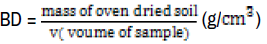
Table 2 shows the determination of soil moisture contents before and after irrigation at initial and middle crop growth stages. Soil wet sample was weighed and taken from field and dried in the Bahir dar university high way laboratory and weighed. Then after the percent soil moisture content in wet basis was determined by weight of wet soil minus weight of dry soil and then divided by weight of dry soil. Finally the soil moisture contents determined as averaged the two initial and middle stage of the percent soil moisture content in wet basis.
The water application efficiencies (Ea) in the selected fields were, then, calculated using the Equation below [9].
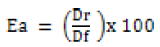
Where:
Ea= Water application efficiency (%)
Dr = Depth of water stored in root zone (mm)
Df = Total depth of water applied in the field (mm)
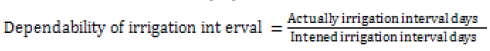
Dependability of Irrigation Interval: The pattern in which water is delivered overtime is directly related to the overall consumed ratio of the delivered water, and hence has a direct impact on crop production. The primary indicator proposed for use in measuring dependability of the water deliveries are concerned with the duration of water delivery compared to the plan, and the time between deliveries [10].
Computed or Intended irrigation interval was calculated with cropwat requirement in the area. To determine reference crop evapotranspiration (ETo) Cropwat model for window 8.0 was used. Crop factor (Kc) for every growth stage can been taken from Allen et al. (1998) and then, ETc would be calculated using equation 9.
ETc = ETo x Kc
Where; ETc is crop evapotranspiration in mm, Kc is crop factor in fraction and ETo is reference crop evapotranspiration in mm.
After setting out of crop evapotranspiration, it is possible to determine net irrigation water requirement by subtracting effective rainfall during the investigational season and it can be expressed by using equation 10.
NIR= ETc − Pe (10)
Where; NIR is net irrigation water requirement, and
Pe is effective rainfall in mm.
After calculating the crop water need which is Etc (mm/day) determining the crop growth length was another task. Then the irrigation interval or computed or intended irrigation interval was determined in Koga irrigation scheme by dividing the crop water need with crop growth length. Rather the Actual irrigation interval was taken by interviewing farmers, by what time difference they irrigate their crop; from here the actual irrigation interval is differ from farmer to farmer, therefore, the average was taken for each crop
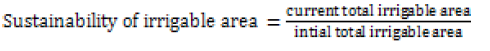
Sustainability: Sustainability is a complex issue, under scarce data [11-13]. Suggested that a ratio of current irrigated area to initial total irrigated area is a good indicator of irrigation scheme sustainability. In fact, the degree to which the initially planned (irrigated) area of schemes is sustained years after the implementation of a scheme is an important issue for the success of an irrigation scheme. Sustainability of irrigable area is the ratio of current total area under irrigation to the initial total irrigable area, That is an indicator for technical performance of the scheme.
Method of Data Analysis
Data collected to evaluate the technical adequacy of the scheme were analyzed descriptively.
Technical Efficiency The parameters assessed for technical efficiency of the scheme included water application efficiency, dependability of duration and dependability of irrigation interval for the scheme.
Water application efficiency: The application efficiency of the scheme was measured by using Parshal flume for discharge measurement. (Table 1) Table 3 below shows the depth of water in the root zone (depth stored), the way calculated was first soil sample was taken from two points which was recommended by FAO for Cabbage (which was effective rooting depth for crops) 0-50 and 50-80 cm before and after irrigation. And then the difference was calculated from the greater value to the minimum value which was moisture difference. Secondly percent of soil moisture content in volume basis was taken by multiplying the moisture difference with bulk density of the soil. Thirdly to find the moisture content in depth form percent of soil moisture content in volume basis multiplied by sample taken soil depth. Finally Depth stored or depth of water in the root zone determined by summed up the 0-50 to 50-80 soil depths (Tables 2 &3).
| Test | Initial | Middle | Initial | Middle | ||||||||||
|---|---|---|---|---|---|---|---|---|---|---|---|---|---|---|
| Soil moisture sample | Soil wet wt | Soil dry wt | % soil moisture content (wt basis) | soil wet wt | soil dry wt | % soil moisture content (wt basis) | Average moisture | Soil wet wt | Soil dry wt | % soil moisture content (wt basis) | soil wet wt | soil dry wt | % soil moisture content (wt basis) | Average moisture |
| plot 1 (0-50) | 125.7 | 87.5 | 43.6 | 127. 2 | 74.7 | 52.5 | 43.05 | 120 | 88.1 | 36.2 | 125. 2 | 86. 7 | 38.5 | 37.5 |
| plot 1 (50- 30) | 143.7 | 100. 8 | 42.6 | 144. 4 | 95.5 | 48.9 | 45.75 | 107.9 | 78.4 | 37.6 | 110. 3 | 69. 7 | 40.6 | 39.1 |
| plot 2 (0-50) | 139.8 | 95.9 | 45.8 | 141. S | 91.7 | 50.1 | 47.95 | 101.8 | 74.8 | 36.1 | 105. 4 | 65. 6 | 39.8 | 37.9 |
| plot 2 (50- 30) | 136.4 | 93.8 | 45.4 | 140. 8 | 92.4 | 48.4 | 46.9 | 100.8 | 73.6 | 37 | 103. 9 | 62. 9 | 41 | 39 |
| Plot 3 (0-50) | 121 | 83.8 | 44.4 | 125. 3 | 77.5 | 47.8 | 46.1 | 101.8 | 74.2 | 37.2 | 106. 8 | 69. o | 37.8 | 37.5 |
| plot 3 (50- 30) | 134.6 | 93.2 | 44.4 | 133. 9 | 90.1 | 43.8 | 44.1 | 101.5 | 73.1 | 38.8 | 111. 4 | 70. 1 | 41.3 | 40.1 |
| Depth of soil(cm) | Mass of oven dried soil(g) | Volume of sample(cm^3) | Dry bulk density (g/ cm^3) |
|---|---|---|---|
| 0-50 | 1121 | 938.5 | 1.194 |
| 1116 | 938.5 | 1.189 | |
| 1226.2 | 938.5 | 1.306 | |
| Total sum | 3463.3 | 938.5 | 3.69 |
| Average | 1154.4 | 938.5 | 1.23 |
| 50-80 | 1172 | 938.5 | 1.248 |
| 1169 | 938.5 | 1.245 | |
| 1178.3 | 938.5 | 1.255 | |
| Total sum | 3519.3 | 938.5 | 3.75 |
| Average | 1173.1 | 938.5 | 1.25 |
Table 5, shows the water applied depth, The reasons for the over application of Plot 2 as compared to the area could be attributed to the slope of the land which had gentle slope that makes the advance time longer, the furrow orientation which rotates and makes the length maximum, the expectation of the farmer that more water means more production. the result was calculated as such; first depth of water pass to the field was measured at the inlet by using parshall flume and then readied discharge value on calibration curve (which was depth vs discharge), if the value was not on the line of curve interpolation was needed after that the discharge was multiplied by the time taken to got total volume of water. Finally the applied depth was determined by dividing the total volume of water with area of irrigated field (Table 4).
| Plot Number | Area m2 |
T (Se) |
Q (l/Se) |
Depth (mm) |
Total Volume     (Lit) |
Applied Depth (mm) |
Depth stored (mm) |
|---|---|---|---|---|---|---|---|
| Plot 1 | 1.221 | 16385.2 | 11.3 | 1130 130 |
185152.44 0850 |
151.64 41.646 1.646 |
89.7 |
| Plot 2 | 816 | 16090.4 | 7.5 | 90 | 120678.24 | 147.89 | 91.4 |
| Plot 3 | 810 | 12025 | 8.1 | 105 | 97402.5 | 120.25Â Â Â Â Â Â Â Â Â Â Â Â Â Â Â Â Â | 62.8 |
Hence, as seen in Table 6, the application efficiency in the schemes ranges from 52.2% to 61.8%. The values obtained are still in the ranges expected of such surface irrigation methods, i.e. 40 percent to 60 percent [14,15]. The reason for good water application efficiency in the scheme, as irrigations is associated to adequacy of technical capacity of farmers resulted from a best practice of extension workers and the required trainings, [16-20] the type of irrigation system employed which is predominantly furrow irrigation, the slopes of irrigable fields, with of knowledge of irrigation time and scheduling by farmers and more (Table 5). Dependability of irrigation interval: The dependability of the irrigation scheme interval is calculated by dividing the average actual irrigation interval of major crops of the scheme to the average designed (computed) interval which was determined for each stage, like for initial stage it becomes 12.6, for crop development stage 8.4, for mid stage 10.1 and late stage 33.3 days at scheme (Tables 6 &7). Rather the Actual irrigation interval was taken by interviewing farmers, by what time difference they irrigate their crop; since the actual irrigation interval practiced varies from farmer to farmer; the average was taken 7.4 days in the scheme. Thus, the dependability of the irrigation scheme is 0.74. This indicates that in scheme they irrigate more frequently than required [21-30].
| Plot Number | Average Applied Depth (mm) |
Average Depth stored (mm) |
Average Application efficiency (%) |
|---|---|---|---|
| Plot 1 | 151.64 | 89.7 | 59.15 |
| Plot 2 | 147.89 | 91.4 | 61.8 |
| Plot 3 | 120.25Â Â Â Â Â Â Â Â Â Â Â Â Â Â Â Â Â Â | 62.8 | 52.2 |
| rop type | Initial stage | Dev’t Stage | Middle stage | Late stage | Crop height | ||||
|---|---|---|---|---|---|---|---|---|---|
| Cabbage | Days | Kc | Days | Kc | Days | Kc | Days | Kc | |
| 40 | 0.7 | 60 | 0.83 | 50 | 0.95 | Â 15 |
0.70 | 0.3 | |
| Irrigation block | FC% | PWP% | TAW% | TAW (mm/m) depth of soil | Infiltration (mm/day) | Net irrigation requirement computed in mm |
|---|---|---|---|---|---|---|
| Ambo mesk | 26.02 | 19.21 | 6.82 | 68.2 | 30 | 506.6 |
Sustainability of irrigation: The modern irrigation scheme of Koga, the actual irrigated area during the design period was 7,000 ha. However currently it is irrigating about 6,200 ha. this shows that the sustainability of the scheme is (7004/6200 ) = 0.86 ~ 86%.Which is relatively highest sustainability of irrigation land value, is operating for the last years and because of imprudent use, a significant proportion of water is lost on farms and it is not enough to cover the total irrigable areas [30-35]. If the current scenario continues, it is likely that ground water will rise and the irrigation system sustainability will be threatened [36-42].
The evaluation was made based on the selected performance indicators such as water application efficiency, dependability of irrigation interval and sustainability of irrigated command area. The results of water application study conducted in Koga irrigation scheme shows that farmers are over applying water than the actual water demand these explain the on farm water loss revealed in this study. In the scheme relatively highest sustainability of irrigation land value, is operating for the last years and because of imprudent use, a significant proportion of water is lost on farms and it is not enough to cover the total irrigable areas. If the current scenario continues, it is likely that ground water will rise and the irrigation system sustainability will be threatened. The water delivery adequacy at farm levels is very important from the farmers’ point of view; as farmers are generally interested in the amount of water delivered at the head of their fields. Major problem decreasing the efficiency of the scheme is assessed in interview was market access problem which is 43.3%. Accordingly, the net return they get from irrigation becomes low and discourages farmers and cut down their contribution and effort to make the scheme more efficient.
Capacity building in terms of training of irrigation planners and managers on matching irrigation water diversions with field demands over the cropping seasons is required. Water diversions should consider cropping patterns and hence irrigation demands. For this training of local administrations, development agents and IWUA on compilation of appropriate agronomic data and hence cropping pattern before the start of each irrigation season is required. So before irrigation, diversion schedules have to be set and implemented. This reduces the excess diversions, saves water and reduces negative impacts such as water logging.
Irrigation & Drainage Systems Engineering received 835 citations as per Google Scholar report


